TEMPERATURE
December was warmer than average by around 1.1 degrees C. 7 days were over 30 degrees and the maximum was 37.7 C on the 25th, which was the hottest Christmas Day since 1945 in Geelong – 71 years.
RAINFALL
A very dry month ended a surprisingly wet year (see the Yearly Summary). Rain fell on only 8 days and metropolitan Geelong received an average 16 mm across the urban area. The latest 30-year average for December is 41.9 mm.
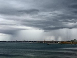
Rain over Geelong on 28th Dec 2016. Anonymous photo credit.
OTHER FEATURES
There were 4 strong wind days and the 8th saw a gust of 83 kph at Breakwater. One thunder day was experienced on the 29th. The massive flash floods in Melbourne on the 29th mostly missed Geelong and only 10 mm fell over 3 days.
RAINFALL DATA
| GEELONG REGION | ||
| Location | Total for Month (mm) | Monthly Average (mm) |
| Aireys Inlet | 25.6 | 34.0 |
| Anakie | 16.2 | 55.0 |
| Anglesea | na | 48.0 |
| Apollo Bay | 41.1 | 63.2 |
| Bacchus Marsh | na | 47.1 |
| Ballan | na | 45.9 |
| Ballarat | 23.4 | 51.6 |
| Bannockburn | na | 42.0 |
| Barwon Heads Golf Club | na | 47.0 |
| Bellbrae | na | 54.0 |
| Beeac | 8.5 | 42.4 |
| Beech Forest | 62.8 | 96.4 |
| Benwerrin | 55.0 | n.a. |
| Birregurra | 11.2 | 42.4 |
| Boonah | 40.6 | n.a. |
| Cape Otway | 31.4 | 52.7 |
| Clifton Springs | na | n.a. |
| Colac | 35.8 | 46.6 |
| Cressy | na | 42.7 |
| Curlewis | 10.2 | 44.2 |
| Dereel | na | 44.2 |
| Drysdale | na | 44.7 |
| Durdidwarrah | 7.2 | 55.1 |
| Forrest | na | 60.3 |
| Gellibrand | na | n.a. |
| Gerangamete | na | n.a. |
| Inverleigh | 7.8 | 45.5 |
| Lal Lal | 27.8 | n.a. |
| Laverton | 36.6 | 45.0 |
| Lethbridge | na | 55.9 |
| Melbourne (City) | 39.6 | 59.0 |
| Meredith | na | n.a. |
| Meredith (Darra) | 15.6 | 51.8 |
| Moriac | 34.2 | n.a. |
| Morrisons | na | 47.0 |
| Mt Buninyong | 25.8 | n.a. |
| Mt Cowley | 51.4 | 85.0 |
| Mt Gellibrand | 27.4 | na |
| Mt Mercer | 35.0 | n.a. |
| Mt Sabine | 31.2 | 90.0 |
| Point Lonsdale | 32.8 | 45.0 |
| Pollocksford | 15.0 | n.a. |
| Ocean Grove | 38.4 | 45.5 |
| Queenscliff | na | 43.4 |
| Shelford | 14.6 | 45.0 |
| Sheoaks | 12.0 | 29.2 |
| Skipton | na | 46.4 |
| St Leonards | 9.5 | 45.0 |
| Sutherland’s Creek | 10.6 | na |
| Teesdale | na | 39.9 |
| Torquay | na | 40.0 |
| Wallington | 21.0 | n.a. |
| Wyelangta | na | 120.7 |
| West Barwon Dam | 39.4 | 65.0 |
| Winchelsea | 27.4 | 41.1 |
| Wooloomanata | na | n.a. |
| You Yangs | na | n.a. |
| GEELONG SUBURBS | ||
| Location | Total for Month (mm) | Monthly Average (mm) |
| Avalon | 5.0 | 28.1 |
| Bell Post Hill | 5.0 | 47.8 |
| Belmont | 7.0 | 44.0 |
| Breakwater Racecourse | 13.4 | 41.0 |
| Connewarre | 11.8 | 52.1 |
| Ceres | na | 44.0 |
| Corio | 5.0 | 42.0 |
| Drumcondra | 22.6 | 41.0 |
| East Geelong | na | 41.0 |
| Grovedale | na | 44.2 |
| Grovedale South | 24.0 | 44.2 |
| Hamlyn Heights | 5.7 | 42.0 |
| Herne Hill | 10.0 | 42.0 |
| Highton | na | 44.2 |
| Lara | 7.0 | 42.0 |
| Lara (Serendip) | na | 42.0 |
| Leopold | 13.0 | 53.9 |
| Leopold East | 21.6 | 42.0 |
| Manifold Heights | 8.9 | 47.8 |
| Moolap | 13.6 | 38.0 |
| Waurn Ponds | 19.6 | 42.2 |
| Whittington | 15.6 | 42.0 |
| Urban Area Average | 16.0 | 41.9 |

