SUMMARY
- Geelong was warmer than average by around 0.2 degree and drier than normal by around 15 mm for the month.

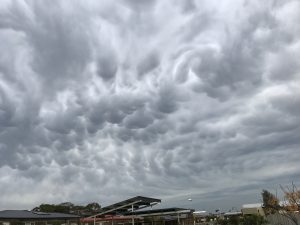
Mammatus sky over Geelong at 7.30 am on 20th Sept. Photo L. Smail.

A meteor seen over Geelong on the 20th. Photo Matthew Donnelly.
TEMPERATURE
A fractionally warmer September was experienced with daily minimums averaging 7.5 C for the month (0.3 C above the 30-year average) and daily maximums averaging 17.2 C (0.1 C above average).
The top temperature reached 23.8 C on the 19th but only 13.0 C on the 17th. Overnight minimum on the 18th only reached 2.0 C but up to 14.2 C on the 20th.
RAINFALL and OTHER FEATURES
A rather poor rainfall averaging around 35 mm across the urban area compared with the most recent 30-year average of 51.1 mm. The wettest 24 hours was recorded on the 16th – 16.0 mm – and there were 21 rain days. As a result Geelong catchments ended the month being 71 % of capacity – better than last year. Light hail was recorded on at least three occasions across Geelong but there were no severe storms and one thunder day on the 1st. One strong wind day with gusts over 60 km/h occurred on the 21st at Breakwater, but there were three other days with gusts over 57 km/h.
RAINFALL DATA
| GEELONG REGION |
 Location Location |
Total for
Month
(mm) |
Monthly
Average
(mm) |
| Aireys Inlet |
30.0 |
(71.9) |
| Anakie |
31.8 |
(64.0) |
| Anglesea |
36.4 |
(70.5) |
| Apollo Bay |
105.8 |
(108.6) |
| Bacchus Marsh |
14.8 |
(41.5) |
| Ballarat |
46.2 |
(73.0) |
| Bannockburn |
35.2 |
(52.0) |
| Barwon Downs |
40.2 |
(61.0) |
| Bellbrae |
54.5 |
(60.5) |
| Bells Beach |
38.2 |
(60.5) |
| Beeac |
na |
(59.9) |
| Beech Forest (Otway Fly) |
148.2 |
(180.8) |
| Boonah |
na |
(n.a.) |
| Benwerrin |
46.4 |
(n.a.) |
| Buninyong |
26.6 |
(n.a.) |
| Cape Otway |
81.2 |
(89.6) |
| Colac |
36.0 |
(68.0) |
| Curlewis Golf Club |
23.4 |
(68.6) |
| Dereel |
60.7 |
(68.6) |
| Forrest (West Barwon) |
73.6 |
(118.0) |
| Inverleigh |
29.4 |
(51.6) |
| Lorne |
36.0 |
(102.2) |
| Lal Lal |
33.0 |
(82.0) |
| Laverton |
27.8 |
(53.0) |
| Melton |
15.4 |
(n.a.) |
| Melbourne (City) |
41.0 |
(59.4) |
| Meredith (Darra) |
30.4 |
(70.4) |
| Moriac |
40.0 |
(56.0) |
| Mt Gellibrand |
35.8 |
(n.a.) |
| Mt Cowley |
68.2 |
(n.a.) |
| Mt Mercer |
43.4 |
(n.a.) |
| Mt Sabine |
68.0 |
(n.a.) |
| Ocean Grove |
46.4 |
(n.a.) |
| Point Lonsdale |
39.0 |
(59.2) |
| Queenscliff |
39.0 |
(59.2) |
| Shelford |
39.1 |
(54.6) |
| Sheoaks |
32.0 |
(n.a.) |
| Skipton |
na |
(n.a.) |
| St Leonards |
43.0 |
(58.0) |
| Sutherlands Creek |
24.4 |
(47.7) |
| Wallington |
32.4 |
(58.0) |
| Wensleydale |
49.4 |
(53.0) |
| Werribee |
24.2 |
(44.4) |
| Wooloomanata |
15.4 |
(46.0) |

| GEELONG SUBURBS |
 Location Location |
Total for
Month
(mm) |
Monthly
Average
(mm) |
| Armstrong Creek |
39.0 |
(45.9) |
| Avalon |
17.6 |
(45.9) |
| Belmont |
28.5 |
(50.2) |
| Bell Post Hill |
21.8 |
(50.0) |
| Breakwater |
39.2 |
(51.1) |
| Charlemont |
34.1 |
(60.3) |
| Corio |
22.6 |
(46.6) |
| Grovedale |
36.2 |
(51.0) |
| Grovedale South |
44.7 |
(51.0) |
| Hamlyn Heights |
37.6 |
(51.9) |
| Herne Hill |
36.2 |
(51.9) |
| Highton |
32.5 |
(51.8) |
| Lara |
16.4 |
(47.5) |
| Leopold |
40.0 |
(50.8) |
| Leopold East |
na |
(50.8) |
| Manifold Heights |
34.7 |
(51.9) |
| Marshall |
34.6 |
(51.0) |
| Moolap |
34.6 |
(52.0) |
| Newtown |
na |
(51.0) |
| North Shore |
24.8 |
(51.0) |
| Waurn Ponds |
26.6 |
(49.7) |
| Whittington |
36.6 |
(50.3) |
| Urban Area Average |
35.0 |
(49.7) |

![]()


