 CLICK TO ENLARGE
Even in the best of years Geelong is a dry place. So at times when the whole of southern Victoria is suffering from a rainfall deficiency, Geelong never escapes the general trend. If anything, we suffer more.
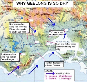
Our main prevailing winds come from the northwest and the southwest. This means they have to cross some of the highest country in the state. As winds rise the moisture they carry is “squeezed” as the temperature drops and this process (called orographic lifting) enhances cloud formation and precipitation.
The accompanying map shows what happens after these winds bring rain to the highlands. They lose altitude as they approach Geelong and the warming mechanism decreases the likelihood of rain. In fact, Ballarat’s annual average is about 710 mm while Geelong’s is less than 550 mm. In our Otways water catchment the totals average over 1200 mm.
Often if you look to Geelong’s southwest or northwest you will see large lines of “cauliflower-top” cumulus clouds expanding as they rise over the Otways and the Great Dividing Range. But often they don’t get to Geelong, or they seem to blow away before they get here. This is “desaturation” in action; in our case it causes a “rain shadow” effect that is a direct result of topography and physics.
This doesn’t mean the clouds disappear altogether; their lower altitude just means they have lost the means of cooling to trigger off a heavy fall of rain.
Obviously this doesn’t happen all the time, but it is almost impossible for Geelong ever to receive more rain than the Otways from the same cloud system. Sometimes a summer thunderstorm, caused by rapid uplift of warm moist air, can occur in Geelong and not elsewhere.
