RAINFALL
Another month of questionable rainfall figures has plagued the Geelong AWS at Breakwater. On 14 days in August the gauge registered nil rainfall, but surrounding close suburbs totalled between 8 and 12 mm on those days. The Bureau of Meteorology had hopefully fixed the problem later in the month. Nevertheless a very poor 16 mm was the recorded average across the urban area, or 30 mm below the latest 30-year figures. Rain fell on 20 days and there was hail on the 2nd, together with wind gusts up to 72 kph on the same day. Below average rain was recorded throughout the whole region from the Bellarine, the Golden Plains and the Otways. The water situation is now at a disappointing level – 62% of capacity – although spring falls are looking slightly more promising. The overall winter situation for rainfall and temperature is summarised below. It shows a colder but drier winter than the 30-year average:
| WINTER 2015 |
|
|
|
|
|
|
MAX TEMPS |
MIN TEMPS |
PRECIPITATION |
|
2015 |
30-yr av |
2015 |
30-yr av |
2015 |
30-yr av |
| JUNE |
14.3 |
14.5 |
6.7 |
6.3 |
38.0 |
46.1 |
| JULY |
13.3 |
13.9 |
5.4 |
5.6 |
44.0 |
43.6 |
| AUGUST |
14.2 |
15.0 |
6.5 |
6.0 |
16.0 |
46.9 |
| WINTER |
13.9 |
14.5 |
6.2 |
6.0 |
98.0 |
136.6 |
TEMPERATURE
Colder than average temperatures characterised August and winter as a whole. It was Geelong’s coldest August since 2010 – days were colder than normal but nights were slightly warmer. The highest maximum was 18.7 C on the 20th and 21st. Lowest minimum was 0.6 C on the 19th – the only frost day. Overall winter temperatures were colder than the 30-year average by 0.2 degree C and it was the coldest since 2010.

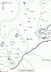
Isohyets for August, 2015
RAINFALL DETAILS FOR AUGUST 2015
| GEELONG REGION |
| Location |
Total for Month (mm) |
Monthly Average (mm) |
| Aireys Inlet |
27.2 |
78.5 |
| Anakie (Granite Road) |
18.2 |
46.0 |
| Anakie (De Motts Road) |
31.4 |
46.0 |
| Anglesea |
na |
69.0 |
| Apollo Bay |
99.4 |
124.7 |
| Bacchus Marsh |
na |
39.0 |
| Ballan |
43.5 |
55.6 |
| Ballarat |
38.4 |
76.4 |
| Bannockburn |
38.2 |
47.0 |
| Barwon Heads |
27.6 |
63.0 |
| Bells Beach |
na |
60.4 |
| Beeac |
29.8 |
70.1 |
| Beech Forest |
175.2 |
210.0 |
| Benwerrin |
90.0 |
164.0 |
| Birregurra |
41.7 |
80.3 |
| Boonah |
57.2 |
150.0 |
| Cape Otway |
75.4 |
102.1 |
| Colac |
44.4 |
59.5 |
| Clifton Springs |
19.6 |
52.0 |
| Cressy |
25.2 |
52.0 |
| Curlewis |
na |
42.0 |
| Dereel |
60.0 |
62.0 |
| Drysdale |
18.0 |
54.9 |
| Durdidwarrah |
20.2 |
53.3 |
| Forrest |
106.0 |
146.2 |
| Forrest (West Barwon) |
106.0 |
146.2 |
| Inverleigh |
29.6 |
na |
| Johanna Heights |
180.0 |
na |
| Lal Lal |
7.0 |
na |
| Lavers Hill |
na |
na |
| Laverton |
15.4 |
48.0 |
| Melba Gully |
na |
n.a. |
| Melbourne (City) |
38.2 |
51.0 |
| Meredith (Darra) |
39.0 |
61.7 |
| Moriac |
na |
58.0 |
| Morrisons |
na |
80.3 |
| Mt Cowley |
121.2 |
185.0 |
| Mt Gellibrand |
30.4 |
na |
| Mt Mercer |
43.6 |
70.3 |
| Mt Sabine |
266.0 |
210.0 |
| Ocean Grove |
28.1 |
45.0 |
| Pollocksford |
24.2 |
n.a. |
| Point Lonsdale |
na |
59.0 |
| Queenscliff |
31.6 |
61.4 |
| Scotsburn |
43.0 |
80.3 |
| Shelford |
30.0 |
51.0 |
| Sheoaks |
32.8 |
47.0 |
| Skipton |
40.6 |
48.0 |
| St Leonards |
na |
60.0 |
| Sutherlands Creek |
28.4 |
46.0 |
| Torquay |
18.4 |
64.0 |
| Wallington |
22.5 |
56.0 |
| Warncoort |
na |
89.8 |
| Winchelsea |
na |
57.2 |
| Wooloomanatta |
17.0 |
47.2 |
| Wyelangta |
206.4 |
231.4 |
| You Yangs |
16.0 |
38.0 |
|
| GEELONG SUBURBS |
| Location |
Total for Month (mm) |
Monthly Average (mm) |
| Avalon |
12.0 |
48.3 |
| Bell Post Hill |
17.0 |
50.9 |
| Belmont |
11.5 |
49.4 |
| Breakwater |
12.0 |
46.9 |
| Connewarre |
na |
44.3 |
| Corio |
22.5 |
42.0 |
| East Geelong |
10.8 |
47.3 |
| Grovedale |
19.0 |
51.5 |
| Grovedale South |
21.0 |
51.5 |
| Hamlyn Heights |
17.1 |
46.0 |
| Herne Hill |
12.0 |
46.0 |
| Highton |
14.5 |
51.5 |
| Lara |
9.0 |
39.6 |
| Lara (Serendip) |
na |
39.6 |
| Leopold |
na |
49.5 |
| Leopold East |
22.2 |
49.5 |
| Manifold Heights |
19.2 |
46.0 |
| Moolap |
16.2 |
45.0 |
| Waurn Ponds |
17.8 |
48.1 |
| Whittington |
na |
51.0 |
| Urban Area Average |
16.0 |
46.9 |
|

